Farm Mapping
AgriMAP by Mosaic Mapping provides accurate and cost effective farm mapping solutions using leading edge GPS and digital mapping technology. Our farm maps provide farmers with accurate and up to date information on their paddock acreage, irrigation 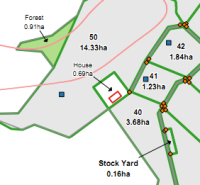 and drainage systems, forest blocks, water supplies, fencing and roading assets for effective planning and land management.
Why Map Your Farm?
Some key applications of farm maps include:
Measuring Paddock Acreage & Forest Areas - Accurately mapped paddock areas can be used to help determine the optimum amounts of fertiliser, seed or spray to be used on each paddock.
Presentation - Farm maps provide an effective way to summarise your knowledge of your property to others. They can be a useful tool when communicating with potential investors, irrigation engineers, government departments, contractors and employees.
Costing Proposed Improvements - Accurate measurements can be taken from maps when costing new fencing, irrigation systems, farm tracks etc.
Precision Agriculture - Accurate farm maps provide the framework for precision agriculture. For example, GPS is used to survey a paddock and sample points to create a fertility map. The map is used by a fertiliser spreader that is controlled by a laptop computer, with a GPS receiver, to deliver varying amounts of fertiliser depending on the nutrient deficiency within any area.
Key Features of AgriMAP Farm Mapping Service
Accuracy - We can map to the accuracy required by your farming enterprise - all the way up to centimetre accuracy.
Cost - GPS and digital mapping technologies enable us to electronically record data and to efficiently convert this information into accurate maps at a cost that is affordable to land owners. Please contact us for a free no obligation quote.
Maps - We supply large laminated maps suitable to take out on the farm, pads of maps that are useful for giving to contracters to assist them find their way around the property and if required engraved whiteboards.
Farm Management Systems - Our digital map data can be supplied in a wide variety of file formats for import into Farm Management Systems and for use in other applications such as Acrobat, Word, Excel, Publisher, PowerPoint and ArcGIS Explorer (free map viewing software).